Oil shale, or kukersite, is the most important mineral resource of Estonia, which has been the main source of electricity since 1924, but also a source of environmental problems
The oil shale industry has significantly affected the socio-economic and natural environment of the Ida-Viru County for almost a century [1]. Due to oil shale mining and processing and activities related to oil shale energy, landscapes, soils, vegetation, and water regime in the Ida-Viru County have changed; air, soil, surface water, and groundwater pollution have had a significant impact on forest, mire, and aquatic ecosystems. Many of the pressures caused by the oil shale industry were created decades ago, but their impact on the state of the environment extends to the present day [1].
The total area of the Estonian oil shale deposit is 2,070 km2, and the mined area in Ida-Viru County is more than 440 km2. Approximately 290 km2 of the mined area has been mined underground and approximately 150 km2 has been mined by quarrying. On about 140 km2 of the mined area, the mining has stopped. There are more than twice as many protected areas on the non-mined areas of the Estonian oil shale deposit as in the Estonian average, which points to the increasingly intense conflict between nature conservation and opening new mining areas in the region. Protected areas form 29% of the area of the Estonian oil shale deposit, and 38% of the non-mined areas.
A surface water catchment area of 4,000 km2 is connected to the oil shale deposit, which makes up 9% of Estonia’s land area. The areas mined so far and currently being mined are connected to a surface water catchment area of 2,500 km2. Surface water bodies affected by the oil shale industry are predominantly in a poor or bad condition [1]. In order to extract oil shale, the groundwater level in quarries and mines must be lowered and the water interfering with mining must be diverted elsewhere. Dozens of ditches and sediment basins have been built for this purpose, and the beds of several rivers have been changed. As many natural water bodies are used for water disposal, their water composition has also changed. Specifically, the water pumped out from underground mines contains large amounts of sulphates and calcareous suspended solids. Most of the suspended solids and some sulphates remain in the sediment basins, but the water entering the water bodies is still rich in bicarbonates and sulphates. In oxygen-rich water, sulphates do not affect the aquatic ecosystem, but mine water discharged into water bodies can become hazardous to biota if the sulphates contained in it end up in oxygen-poor conditions with stagnant water. In that case, sulphates may form hydrogen sulphide (H2S), which is incredibly dangerous to aquatic life in acidic water. If sediment basins do not function efficiently enough, aquatic ecosystems can also be negatively affected by the suspended solids carried with water and settling to the bottom of water bodies, covering natural benthic habitats with lime mud waste. [2]
For decades, the water pumped out of the mines of Estonia and previously Viru has been led through six lakes in the Kurtna lake system. As a result, significant amounts of sulphates have accumulated in the sediments of Lake Nõmmejärv, which is the first in the lake chain, and the sediments of the more distant parts of the lake smell like rotten eggs, which is an indicator of H2S release. So far, it has not become a threat to biota, as mining water still flows through the lake, containing oxygen in addition to carrying undesirable substances, which prevents the conversion of sulphates and also keeps the water hard. Paradoxically, it may be dangerous to stop pumping mine water into the lake, as this would decrease the water exchange and increase the likelihood of oxygen deprivation. [2]
However, the effect of the decreased groundwater level can be noticed in the lakes in the eastern part of the Kurtna lake system. So far, Lake Liivjärv and Lake Kihljärv have been the most affected. Due to the combined effect of oil shale and peat mining, the water level of Lake Liivjärv has dropped by more than three metres. As a result, the low-nutrient lake with clear water has become a dark-watered lake with increased nutrition, which has significantly depleted the lake’s large vegetation (incl. the loss of the lake quillwort, a protected category II species). Meanwhile, Lake Kihljärv has essentially dried up over the last ten years and become a fen. [3]
Oil shale mining has the greatest impact on naturally occurring mire communities at the eastern side of Selisoo, where a decrease in the mire water level has been observed due to the approach of the Estonia mine. While it was originally planned to move the mine under the mire, assuming that the mining activity would not have an impact on the mire, the studies concluded that a negative impact could not be ruled out [4] and the idea was abandoned.
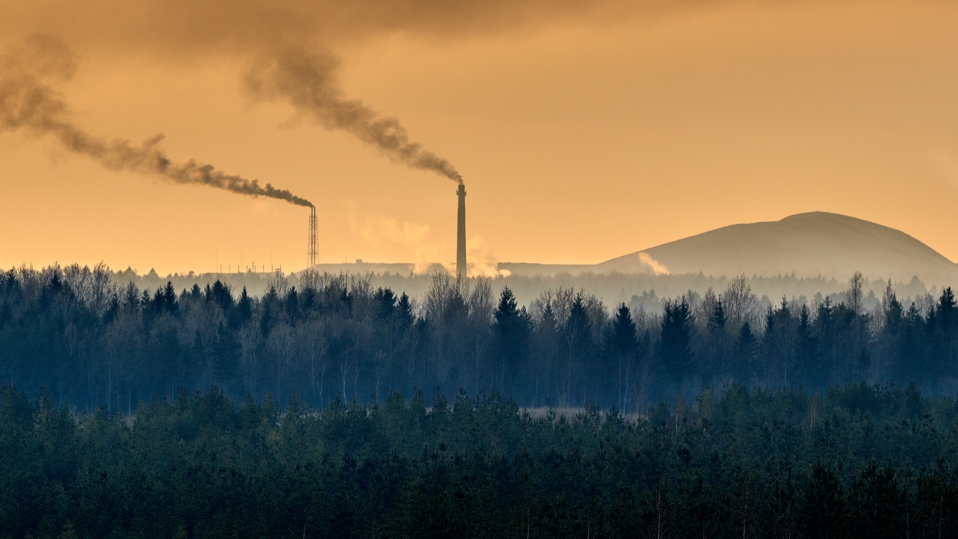
In the past, bog communities near oil shale power plants have also been significantly affected by the alkaline air pollution caused by fly ash from oil shale combustion. As a result, several naturally acidic bog communities became more alkaline, peat mosses were destroyed, and species characteristic of the limestone-fed fens of Western Estonia (e.g. bog-myrtle, moor birch, marsh helleborine, common butterwort) appeared in the vegetation. After the installation of ash removal filters on the chimneys of power plants and the continuous improvement of their efficiency, the problem of alkaline air pollution is being alleviated and bog communities with peat mosses are recovering. [5]
One of the most notable effects of underground mining is also land subsidence. The area of areas affected by land subsidence caused by underground mining is more than 100 km2. The subsidence of 0.5–1.2 m has occurred primarily in areas mined decades ago. The subsidence of the ground causes kettle holes and bath-shaped elements of closed relief; the bottoms of those sites may become excessively moist areas and there might be a need for additional land improvement systems. At present, so-called perpetual support units are used in room and pillar mining, where oil shale losses are higher, but the environmental impact is significantly lower.
Oil shale ash and semi-coke deposits with a total area of 21.5 km2 have been built for the disposal of waste generated during the use of oil shale. Nine coal stock deposits have burned decades ago and contain contaminated soil from which hazardous substances are transferred to the aquatic environment and the ambient air.
Surface mining destroys the existing natural landscape and reduces species diversity. At the end of mining, poor soil quality and a changed landscape will remain, which will have a negative impact on biodiversity. The mining landscape may no longer be suitable for the species that lived there, but may be a suitable habitat for new species. After mining, quarries need to be rehabilitated – in quarries where there was predominantly forest land before mining, the rehabilitated land also tends to be forest land. The experience with turning a mine to arable land is small – so far, only 1% of the restored areas have been converted to arable land. In addition, there is a common approach of turning a quarry into a water body that provides a habitat for animal and bird species.
Oil shale energy is by far also the largest source of greenhouse gas emissions in Estonia – in 2019, oil shale energy accounted for almost 66% of Estonia’s CO2 emissions [6] and emissions to air in general, where 60% of SO2 emissions [7] also came from oil shale energy.
In 2017–2019, oil shale mining decreased by approximately 40% and in 2019, CO2 and SO2 emissions decreased by approximately 50%. Estonia is moving towards a low-carbon economy.
Last modified: 13.01.2022
__________________________________________________
[1] Metsur, M., Tamm, I. 2014. Põlevkivi kasutamise riikliku arengukava 2016-2030 keskkonnamõju strateegilise hindamise aruanne. Tallinn.
[2] Terasmaa, J. jt. 2018. Projekti "Nõmmejärve enesereostuse uuring" aruanne. infoleht.keskkonnainfo.ee/GetFile.aspx?id=-1965572416
[3] Projekti hüdrogeoloogilise ja limnoloogilise uuringu läbiviimine koos loodusdirektiivi järvedele lubatava veetaseme kõikumise vahemiku määramisega Kurtna maastikukaitsealal. Lõpparuanne. 2019. infoleht.keskkonnainfo.ee/GetFile.aspx?id=2083011718
[4] Kalm, V. 2012. Ratva raba hüdrogeoloogilised uuringud ja Selisoo seiresüsteemi rajamine. Tartu Ülikooli Ökoloogia ja Maateaduste Instituut. Tartu. www.geoloogia.ut.ee/sites/default/files/geoloogia/ratvaseliaruannetdcgeoloogia.pdf
[5] Paal jt. 2007. Õhusaaste mõjust Puhatu looduskaitselala ja Agusalu ning Kurtna maastikukaitseala soodele.